
Order Parts Through: Shop.Deere.com

Search
Choose a Location
R&S Blog
Satellite Imagery
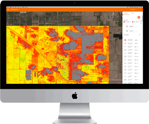
The Operations Center continues to help farmers maximize their time and money by offering Satellite Imagery mapping tools. FarmShots, CropSAT and Satshots are a few highlights from the “more tools” area of the Operations Center at MyJohnDeere.com. With Satellite Imagery mapping, farmers can make informed decisions about what product to apply, when to apply it, and how much should be applied, all while cutting field scouting time by up to 90 percent.
How does Satellite Imagery work? Simply stated, Satellite Imagery utilizes infrared and red-light to measure biomass, or the amount of vegetation in a given field. Satellite cameras project infrared light which reflects off of vegetation. Red-light is also projected from the satellite, but the cholorfyll from plants absorb it. As crops progress, more red-light is absorbed and more infrared light is reflected back to the satellite. Analyzing this correlation of reflected light, biomass maps are created. FarmShots, CropSAT and Satshots then have the ability to export these satellite maps to create custom, prescription application plans. Ultimately, these maps give farmers reassurance of crop progression throughout the year.
To learn more about Satellite Imagery or for pricing or trial information, visit the “more tools” area of the Operation Center at MyJohnDeere.com or contact your regional IS Consultant.
Go Back to List
- Blog Archive
- Boost Your Planting Efficiency with ExactShot Precision Upgrades
- The Exciting Transition from John Deere Property Center to John Operations Center
- Revolutionizing Commercial Landscaping: John Deere Unveils New Electric and Autonomous Mowers
- Riesterer & Schnell Acquires Eis Implement to Strengthen Service in Northeast Wisconsin
- Meet Every Challenge: The John Deere 4052R Compact Tractor Can Cover All Your Needs
- Transforming Property Management with the John Deere 1025R
- John Deere Parts Catalog Spring 2025
- John Deere Recognizes Riesterer & Schnell Technician, Matt Zellner as a Territory Champion
- John Deere introduces the new Gator XUV845 and XUV875 Utility Vehicles
- Farm Rescue Ready to Serve Wisconsin Farmers
- JDLink Connectivity Revolutionizing Agricultural Efficiency
- Building and Maintaining Your Garden with a John Deere Compact Utility Tractor
- John Deere 8RX with Wide Row in Potatoes
- Pound Retirement